Inside Truly3D — From Mobile Mapping Capture to Usable Insight

Capturing LiDAR data is only the first step. Without the right software to process, visualize, and extract insight from that data, even the most precise point cloud is just a large, unwieldy file. Truly3D is built specifically to close that gap for mobile mapping data — taking a corridor-scale capture and turning it into something a team can actually use.
Why a Purpose-Built Viewer Matters
Generic point cloud software can display data, but mobile mapping datasets — often covering miles of corridor, paired with 72MP panoramic imagery — have specific demands: handling large file sizes smoothly, aligning point cloud and imagery precisely, and supporting the kind of asset-level review that infrastructure inspection requires. Stitching together separate third-party tools to handle capture, alignment, classification, and visualization introduces friction at every handoff — and increases the chance that something gets lost or misaligned along the way.
From Capture to Insight
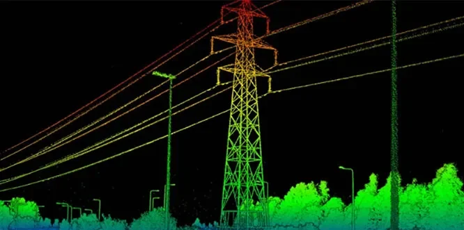
The workflow starts with the mobile LiDAR capture itself — point cloud data and panoramic imagery collected in a single drive-through pass. Truly3D handles the processing step, aligning the point cloud with the overlaid imagery so every geometric feature has a corresponding visual reference. From there, AI-based point cloud classification and asset detection identify and flag relevant features — poles, conductors, vegetation, other assets — directly within the same environment, rather than requiring an export to a separate analysis tool.
Built for the Scale Mobile Mapping Produces
Because mobile mapping is designed to cover large areas, the resulting datasets are correspondingly large. Truly3D is built around that reality — designed to let a reviewer navigate a corridor-scale dataset, jump between flagged assets, and confirm classifications visually, without the software buckling under the size of the data it's displaying.
Who It's Built For
Truly3D is suited to teams running corridor- or region-scale infrastructure surveys — telecom operators, utilities, and municipalities — where the volume of captured data is the central challenge, and the priority is moving efficiently from raw capture to a reviewable, actionable dataset.
Request Call Back
Related Blogs
How Telecom Operators Use LiDAR for Pole and Conductor Inspection
How Telecom Operators Use LiDAR for Pole and Conductor Inspection
Read More
Mobile Mapping vs. Handheld LiDAR — Which One Fits Your Survey?
In today's fast-paced infrastructure and geospatial industry, accuracy and efficiency...
Read More